

ECharts 是一个使用 JavaScript 实现的开源可视化库,底层依赖矢量图形库 ZRender,提供直观,交互丰富,可高度个性化定制的数据可视化图表。
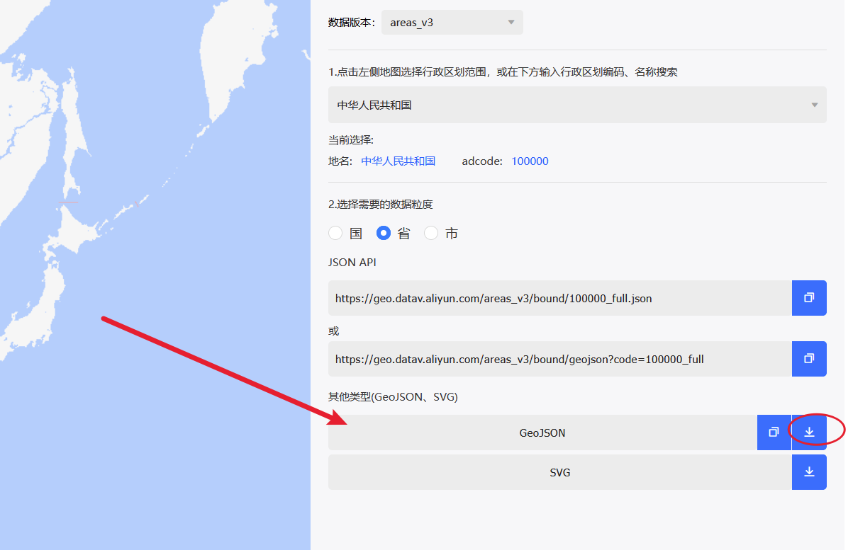
GeoJSON 是一种对各种地理数据结构进行编码的格式,基于 Javascript对象表示法(JavaScript Object Notation, 简称 JSON)的地理空间信息数据交换格式。
阿里云DataV——阿里巴巴集团旗下数据可视化产品,成熟的企业级数据可视化解决方案以及国产化环境部署,无需编程的一站式智能数据可视化平台。
这里我们使用阿里提供的数据JSON文件,放在主题assets/geo/china.json
2. 数据来源、思路
自定义字段可以添加坐标经纬度信息;标签可以分类标记点类型
利用 ECharts GeoJSON 地图渲染功能,展现多个标签标记点。
实现legend图例显隐控制图层显隐。
设置中心经纬度支持地图中心点、缩放级别自定义。
绘制航迹线连接不同点。
高亮行政区(adcode)划城市,标签区分。
3. 项目分析
获取游记文章里面的自定义字段:
► 显示剧情透露
代码: 全选
//获取游记文章里面的自定义字段的经纬度和第一张图片、文章标题、链接
    $tripDataArr = [];
    while ($footprint->next()) {
        $myTrack = $footprint->fields->footprint;
        if (!$myTrack || strlen($myTrack) < 3) continue;

        $tripDataArr[] = [
            'coords' => explode(',', $myTrack),
            'title' => htmlentities($footprint->title),
            'excerpt' => mb_substr(strip_tags($footprint->excerpt), 0, 20, 'utf-8'),
            'image' => (preg_match('/!\[.*?\]\((.*?)\)/', $footprint->content, $md) ? $md[1] : (preg_match('/<img.*?src=["\'](.*?)["\'].*?>/', $footprint->content, $html) ? $html[1] : null)),
            'link' => $footprint->permalink
        ];
    }

开启exif识别第一张图片exif信息的经纬度:
► 显示剧情透露
代码: 全选
//开启exif识别第一张图片exif信息的经纬度,是有摄影的功能;
$pictureDataArr = [];
$this->widget('Widget_Archive@PicturePosts', 'pageSize=100&type=tag', 'slug=picture')->to($picturePosts);

while ($picturePosts->next()) {
    $content = $picturePosts->content;

    // 正则匹配img标签,提取图片链接,注意,这里我是使用本地图片
    if (preg_match('/<img[^>]+src=["\']([^"\']+)["\'][^>]*>/i', $content, $imgMatch)) {
        $imgUrl = $imgMatch[1];

        // 替换成服务器本地路径(未优化网络图片,因为难搞,需要下载后识别)
        $localPath = str_replace($this->options->siteUrl, __TYPECHO_ROOT_DIR__ . '/', $imgUrl);

        if (file_exists($localPath)) {
            $exif = @exif_read_data($localPath);
            if ($exif && isset($exif['GPSLatitude'], $exif['GPSLongitude'], $exif['GPSLatitudeRef'], $exif['GPSLongitudeRef'])) {

                function gps2Num($coordPart) {
                    $parts = explode('/', $coordPart);
                    if (count($parts) == 2 && $parts[1] != 0) {
                        return floatval($parts[0]) / floatval($parts[1]);
                    }
                    return floatval($coordPart);
                }
                function exifToFloat($exifCoord, $ref) {
                    $degrees = gps2Num($exifCoord[0]);
                    $minutes = gps2Num($exifCoord[1]);
                    $seconds = gps2Num($exifCoord[2]);
                    $float = $degrees + ($minutes / 60) + ($seconds / 3600);
                    return ($ref === 'S' || $ref === 'W') ? -$float : $float;
                }

                $lat = exifToFloat($exif['GPSLatitude'], $exif['GPSLatitudeRef']);
                $lng = exifToFloat($exif['GPSLongitude'], $exif['GPSLongitudeRef']);
//同样获取文章标题等信息
                $pictureDataArr[] = [
                    'coords' => [$lng, $lat],
                    'title' => htmlentities($picturePosts->title),
                    'excerpt' => mb_substr(strip_tags($picturePosts->excerpt), 0, 20, 'utf-8'),
                    'image' => $imgUrl,
                    'link' => $picturePosts->permalink
                ];
            }
        }
    }
}
编写 ECharts 配置:
1. 使用 geo 组件加载地图。
2. 使用 series 绘制多个分类的散点,每类数据对应一个 series,设置颜色和图例。
3. 使用 lines 类型绘制航迹线。
4. 使用 geo 的 regions 配置高亮行政区划城市。
5. 通过 JS 控制对应 series 和 lines 的显示与隐藏。
► 显示剧情透露
代码: 全选
fetch(geoJsonUrl).then(res => res.json()).then(geoJson => {
    echarts.registerMap('china', geoJson);

    const option = {
        tooltip: {
            trigger: 'item',
            triggerOn: 'click',
            enterable: true,
            confine: true,
            backgroundColor: 'rgba(255,255,255,0.95)',
            borderColor: '#ccc',
            borderWidth: 1,
            textStyle: {
                color: '#333',
                fontSize: 13
            },
            formatter: function (params) {
                const data = params.data || {};
                if (data.title && data.link) {
                    const imgHtml = data.image ? `<div><img src="${data.image}" style="width:100%;border-radius:6px;margin-bottom:6px;"></div>` : '';
                    const titleHtml = `<div style="font-weight:bold;margin:4px 0;">
                        <a href="${data.link}" target="_blank" style="text-decoration:none;color:#1976d2;">${data.title}</a>
                    </div>`;
                    const descHtml = `<div style="font-size:13px;color:#555;line-height:1.4;">${data.excerpt || '暂无摘要'}</div>`;
                    return `<div style="max-width:300px;">${imgHtml}${titleHtml}${descHtml}</div>`;
                }
                if (data.fromName && data.toName) {
                    return `${data.fromName} → ${data.toName}`;
                }
                const region = highlightRegions.find(r => r.name === params.name);
                if (region) {
                    return `<div><strong>${region.name}</strong><br>点击查看地域文章</div>`;
                }
                return params.name;
            }
        },
        legend: { //图例显隐
            data: [
                { name: '游记', icon: 'circle', itemStyle: { color: 'rgba(255, 87, 34, 0.5)' } },
                { name: '当前在', icon: 'circle', itemStyle: { color: 'rgba(0, 200, 0, 0.7)' } },
                {
                    name: '航迹线',
                    icon: 'path://M1705.06,1318.313v-89.254l-319.9-221.799l0.073-208.063c0.521-84.662-26.629-121.796-63.961-121.491c-37.332-0.305-64.482,36.829-63.961,121.491l0.073,208.063l-319.9,221.799v89.254l330.343-157.288l12.238,241.308l-134.449,92.931l0.531,42.034l175.125-42.917l175.125,42.917l0.531-42.034l-134.449-92.931l12.238-241.308L1705.06,1318.313z'
                },
                { name: '点亮城市', icon: 'circle', itemStyle: { color: 'rgba(255, 153, 0, 0.5)' } },
                { name: '有摄影', icon: 'circle', itemStyle: { color: '#2196f3' } }
            ],
            selected: {
                '游记': true,
                '当前在': true,
                '航迹线': false,
                '点亮城市': false,
                '有摄影': true
            },
            bottom: 10,
            right: 10,
            orient: 'vertical',
            selectedMode: 'multiple'
        },
        visualMap: {
            min: 0,
            max: 10,
            calculable: true,
            seriesIndex: 3,
            inRange: {
                color: ['#ffffff', '#ffcc00']
            },
            orient: 'horizontal',
            bottom: 130,
            right: 10,
            show: false, //视觉组件开关
            itemWidth: 10,
            itemHeight: 100,
            textStyle: {
                fontSize: 10
            }
        },
        geo: {
            map: 'china',
            roam: true,
            silent: true,  // 禁止地图区域鼠标交互
            center: defaultCenter,
            zoom: defaultZoom,
            scaleLimit: {
                min: 1,
                max: 100
            },
            label: { show: false },
            itemStyle: {
                areaColor: '#eaeaea',
                borderColor: '#999'
            },
            emphasis: {
                itemStyle: {
                    areaColor: '#c8e6c9'
                }
            }
        },
        series: [
            {
                name: '游记',
                type: 'scatter',
                coordinateSystem: 'geo',
                data: tripData.map(item => ({
                    name: item.title,
                    value: [...item.coords, item.title],
                    ...item
                })),
                symbolSize: 15,
                itemStyle: { color: '#ff5722' }
            },
            {
                name: '当前在',
                type: 'scatter',
                coordinateSystem: 'geo',
                data: mapHereData.map(item => ({
                    name: item.title,
                    value: [...item.coords, item.title],
                    ...item
                })),
                symbolSize: 15,
                itemStyle: { color: 'rgba(0, 200, 0, 0.7)' }
            },
            {
                name: '航迹线',
                type: 'lines',
                coordinateSystem: 'geo',
                zlevel: 2,
                data: mapFlyData,
                lineStyle: {
                    color: {
                        type: 'linear',
                        x: 0, y: 0, x2: 1, y2: 0,
                        colorStops: [
                            { offset: 0, color: '#ffffff' },
                            { offset: 1, color: '#00aaff' }
                        ]
                    },
                    width: 2,
                    opacity: 0.6,
                    curveness: 0.2,
                    shadowBlur: 10,
                    shadowColor: '#00aaff'
                },
                effect: {
                    show: true,
                    constantSpeed: 30,
                    symbol: 'path://M1705.06,1318.313v-89.254l-319.9-221.799l0.073-208.063c0.521-84.662-26.629-121.796-63.961-121.491c-37.332-0.305-64.482,36.829-63.961,121.491l0.073,208.063l-319.9,221.799v89.254l330.343-157.288l12.238,241.308l-134.449,92.931l0.531,42.034l175.125-42.917l175.125,42.917l0.531-42.034l-134.449-92.931l12.238-241.308L1705.06,1318.313z',
                    symbolSize: 15,
                    trailLength: 0
                }
            },
            {
                name: '点亮城市',
                type: 'map',
                map: 'china',
                geoIndex: 0,
                data: highlightRegions,
                itemStyle: {
                    areaColor: '#ffcc00',
                    borderColor: null,
                    borderWidth: 0
                },
                emphasis: {
                    itemStyle: {
                        areaColor: '#ff9900'
                    }
                }
            },
            {
    name: '有摄影',
    type: 'scatter',
    coordinateSystem: 'geo',
    data: pictureData.map(item => ({
        name: item.title,
        value: [...item.coords, item.title],
        ...item
    })),
    symbolSize: 15,
    itemStyle: { color: '#42a5f5' }
}
//这里是Exif识别
        ]
    };

    myChart.setOption(option);

//弃用:点击跳转地区
    myChart.on('click', function (params) {
        const region = highlightRegions.find(r => r.name === params.name);
        if (region) {
            window.open(region.link, '_blank');
        }
    });

    document.getElementById('toggleBrightness')?.addEventListener('change', function () {
        const show = this.checked;
        const currentOption = myChart.getOption();
        currentOption.visualMap[0].show = show;
        myChart.setOption(currentOption);
    });
});footprint.zip
5. 后续修复修复无法循环获取EXIF的GPS信息:
► 显示剧情透露
1. 把辅助函数 `gps2Num` 和 `exifToFloat` 放到模板最顶部或循环外,只定义一次:
2. `$pictureDataArr` 循环,改成如下,避免重复定义函数:
代码: 全选
<?php
if (!defined('__TYPECHO_ROOT_DIR__')) exit;

// 建议放这儿
function gps2Num($coordPart) {
    $parts = explode('/', $coordPart);
    if (count($parts) == 2 && $parts[1] != 0) {
        return floatval($parts[0]) / floatval($parts[1]);
    }
    return floatval($coordPart);
}

function exifToFloat($exifCoord, $ref) {
    $degrees = gps2Num($exifCoord[0]);
    $minutes = gps2Num($exifCoord[1]);
    $seconds = gps2Num($exifCoord[2]);
    $float = $degrees + ($minutes / 60) + ($seconds / 3600);
    return ($ref === 'S' || $ref === 'W') ? -$float : $float;
}
?>代码: 全选
$pictureDataArr = [];
$this->widget('Widget_Archive@PicturePosts', 'pageSize=100&type=tag', 'slug=picture')->to($picturePosts);

while ($picturePosts->next()) {
    $content = $picturePosts->content;

    if (preg_match('/<img[^>]+src=["\']([^"\']+)["\'][^>]*>/i', $content, $imgMatch)) {
        $imgUrl = $imgMatch[1];
        $localPath = str_replace($this->options->siteUrl, __TYPECHO_ROOT_DIR__ . '/', $imgUrl);

        if (file_exists($localPath)) {
            $exif = @exif_read_data($localPath);
            if ($exif
                && isset($exif['GPSLatitude'], $exif['GPSLongitude'], $exif['GPSLatitudeRef'], $exif['GPSLongitudeRef'])
                && is_array($exif['GPSLatitude']) && is_array($exif['GPSLongitude'])
            ) {
                $lat = exifToFloat($exif['GPSLatitude'], $exif['GPSLatitudeRef']);
                $lng = exifToFloat($exif['GPSLongitude'], $exif['GPSLongitudeRef']);

                $pictureDataArr[] = [
                    'coords' => [$lng, $lat],
                    'title' => htmlentities($picturePosts->title),
                    'excerpt' => mb_substr(strip_tags($picturePosts->excerpt), 0, 20, 'utf-8'),
                    'image' => $imgUrl,
                    'link' => $picturePosts->permalink
                ];
            }
        }
    }
}